Physical Address
304 North Cardinal St.
Dorchester Center, MA 02124
Physical Address
304 North Cardinal St.
Dorchester Center, MA 02124


Military Sentinel, MANILA – Chinese military forces have integrated an advanced high-altitude reconnaissance drone into combined maritime drills near Scarborough Shoal, underscoring Beijing’s bid to enforce an expanded maritime security buffer well beyond internationally recognized baselines.
The drill, staged over the weekend by the People’s Liberation Army (PLA) Southern Theater Command, paired unmanned surveillance sorties with shipboarding rehearsals and fast-interception routines. Reports from regional defense observers and Chinese state media indicate Beijing is actively testing mechanisms to project administrative and operational control beyond 24 nautical miles from the feature, overlapping the Philippines’ exclusive economic zone (EEZ).
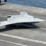
The exercise marked the maiden deployment of the WZ-7 “Soaring Dragon” high-altitude, long-endurance (HALE) unmanned aerial vehicle (UAV) in direct coordination with surface combatants and airborne early warning platforms near Scarborough Shoal.
According to state broadcaster CCTV and technical releases from the Aviation Industry Corporation of China (AVIC), the WZ-7 acts as a high-altitude surveillance node feeding real-time target designation data to tactical networks:
Role: High-altitude reconnaissance, maritime surveillance, and strike cueing.
Wingspan: 22.8 meters featuring a tandem, joined-wing aerodynamic layout.
Cruising Altitude: Above 18,000 meters (59,000 ft), allowing it to loiter above standard commercial air corridors.
Operating Range & Endurance: Exceeding 4,500 kilometers with over 6.5 hours of persistent station time.
Flying well above the reach of standard anti-air systems mounted on coast guard vessels, the Scarborough Shoal drone deployment provided persistent radar tracking and signals intelligence for Chinese surface flotillas enforcing local blockades.
The deployment follows Beijing’s formal gazetting of baseline coordinates around Scarborough Shoal known in Manila as Bajo de Masinloc. Under the United Nations Convention on the Law of the Sea (UNCLOS), Scarborough Shoal is a high-tide feature entitled only to a 12-nautical-mile territorial sea.
However, statements cited in Chinese state publications indicate the PLA is drilling to sustain a 24-nautical-mile contiguous buffer, as well as an outer surveillance cordon that detects Philippine and allied traffic nearly 40 nautical miles out. During Sunday’s maneuvers, China Coast Guard (CCG) personnel rehearsed fast-rope boarding routines and non-compliant vessel interdictions, supported directly by the overhead drone feed.
The Philippine Coast Guard (PCG) reported monitoring several PLA Navy vessels and research ships loitering adjacent to territorial waters. Manila maintains that the 2016 Permanent Court of Arbitration ruling invalidated Beijing’s historic nine-dash claims, deeming restrictions on traditional artisanal fishing around the shoal illegal.
The introduction of dedicated HALE unmanned systems to the Scarborough Shoal dispute fundamentally shifts gray-zone dynamics. By pairing persistent airborne sensors with naval interdiction assets, China can establish continuous domain awareness without burning through the service life of high-value crewed fighter jets.
For the Armed Forces of the Philippines and allied patrols, this sensor web heightens the risk of interception long before supply or patrol craft reach the shoal’s outer lagoons. Looking ahead, regional analysts anticipate Beijing may rotate unmanned systems through expanded maritime outposts in the Spratly Islands, testing whether the U.S.–Philippine Mutual Defense Treaty threshold can be deterred below the kinetic trigger line through persistent aerial surveillance and automated track management.

James Whitfield is a defense news writer at Military Sentinel, covering military technology, naval operations, military aviation, international security, and global defense developments. His work focuses on providing informative reporting, relevant context, and accessible explanations of modern military affairs and emerging defense technologies.
Contact: [email protected]